Saturday, October 30, 2010

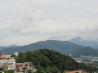
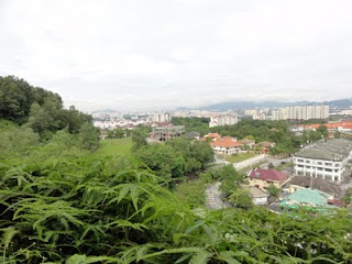
Bukit Dinding Exploration via foot trail


30 Oct 2010

A group of young team ( my future leaders?) were with me this morning

Having breakfast at my house:


ed:


The trail started at 10am after the rain stopped
some of the beautiful scenery along the way.....

and some not so good...b'cos of irresponsible people who take advantage of the quietness of our little forest.


and the trail....


to find time to update this properly...meanwhile enjoy


Saturday, October 16, 2010

all>Click here to view map
Bukit Dinding

click to reposition
Urban renewal / redevelopment areas

837.The former government quarters at Jalan Cochrane shall be redeveloped into a medium density residential neighbourhood focusing on providing medium cost housing. The Tuanku Abdul Rahman Flats, part of which lies within the City Centre, shall also be redeveloped as described in 17.2.2(f). Comprehensive development plans for the upgrading and improvement of the cluster houses at Taman Setapak Jaya shall be drawn up.


Figure 17.2 : Development Strategy, Wangsa Maju - Maluri

d) Stable areas

838.Major development in the zone shall be focused on completion of the development programme for the Wangsa Maju growth area and intensification of development around transit nodes. Opportunities for the development of industrial tourism focusing on the existing Royal Selangor pewter factory at Setapak shall be promoted.

17.3.3 Linkages
a) Green network and open spaces

839.The existing extensive open spaces of RSGC golf course, district park of Taman Tasik Titiwangsa and Bukit Dinding shall be preserved. The natural features of Bukit Dinding shall be protected and parts of the hill preserved as a park. New neighbourhood parks shall be developed at Ampang Hilir and Taman Melati and in the vacated squatter area of Jalan Semarak located to the south of the Air Panas new village.

b) Public transportation

840.The PUTRA LRT serves the eastern area of this strategic zone connecting the City Centre in the south-west to Putra Terminal Station at Gombak in the northern boundary, while the STAR LRT runs along the southernmost boundary of the zone.
841.The Gombak bus terminus which is located next to the Putra Terminal Station is to be designed to integrate with the latter as a multi-modal interchange incorporating taxi, rail and inter-regional bus services.

Monday, October 11, 2010

Headhunter's Trail 13 - 17th February 2010 (Day 5)

Headhunter's Trail 13 - 17th February 2010 (Day 5)

From the Kuala Medalam longhouse, we started our journey home on longtail boat along the Limbang River (Tak pasti betul atau tidak?)...

Upon arriving at the jetty point after some almost 1 hour boat ride, we were hushed in 2 vans heading to Limbang Airport.


Headhunter's Trail 13 - 17th February 2010 (Day 5)

Shuana writes...

From the Kuala Medalam longhouse, we started our journey home on longtail boat along the Limbang River (Tak pasti betul atau tidak?)...

Upon arriving at the jetty point after some almost 1 hour boat ride, we were hushed in 2 vans heading to Limbang Airport.


Headhunter's Trail 13 - 17th February 2010 (Day 4)

Shuana writes:

Our last activity for the trip is trekking along the 11.3km Headhunter's Trail to Terikan River before boating down the river to Bala Lasong Longhouse at Kuala Medalam.

According to Burung, once upon a time, men of different tribes in Sarawak were on race to prove their strength and earned themselves the title "Warriror". Apparently, to do this, they had to fight with men from other tribes and as prove of their chivalry , they had to present the head of other warriors they had fought and killed. War, back then, was a fight for land. Killing and exterminating other tribes were the only ways to expand territory.

We trekked along a suspended bridge (reminiscing my personal Skytrex experience) and took a pit stop at a place called Lubang Cina.

Kayan War parties from the Baram River made their way to Mulu area to attack Murut longhouse and Chinese farmers along the Limbang River. Fearing their safety, the Chinese retreated to a cave not far from the Limbang River not knowing that it was a death call for them. When the water level increased, it flooded the cave and trapped the Chinese. That was how the name Lubang Cina came about.

Anyway, the 11.3km trekking was soon becoming a really exhausting experience to us. Every km seemed to take so long that we saw the repeat of the descend from the Pinnacle..

Patience pays. We took nearly 5 hours to complete Headhunter's Trail. We sang, we ran out of jokes, and in the end, we all went silent.

Lunch awaited us at the Ranger Office at Kuala Mentawai. Then we continued our journey on longtail boat along Terikan River for our accommodation at a longhouse in Kuala Medalam. The 3-hour boat ride was fun. The water was shallow or otherwise, we would've had a white water rafting experience in a longboat.


Camp 5 last day...
Bergambar pada hari terakhir di Camp 5 sebelum memulakan trekking sejauh 11.3km. Camp 5 got its name being the last camp of a mountain trek. The facilities were superb. Trash were separated into tin cans, plastic bags, glasses and papers. (Even I don't do that in my own home.) This is probably an influence by the high volume of foreign tourist in the Camp.

Camp 5 has a kitchenette, clean toilets and the rooms are equipped with basic facilities. Again, I have no complaints. I had enough rest on both nights spent at the camp.


on the river...
Kelihatan di background ialah sungai jernih mengalir betul-betul di depan pondok penginapan kami (Camp 5). Tempat kami berendam untuk menghilangkan kepenatan trekking sejauh 8.4km pada hari Ahad dan memanjat Pinnacle sejauh 2.4km pada hari Isnin. Juga tempat kami bersosial sesama pengunjung yang lain. (Mat Saleh jer lah kebanyakkanya)

Renjer camp...was having lunch..
Di pejabat renjer Kuala Mentawai where we had our lunch break and performed our Zohor prayer. We were so tired and hungry that chicken curry had never tasted better...

Headhunter's Trail 13 - 17th February 2010 (Day 3)


From Shuana's memoirs


The Pinnacle is the collection of 45 meter high limestone needles that cling to the side of Gunung Api (Volcano). The climb to The Pinnacle begins with a 2.4km steep trek. I mean, REALLY STEEP trek, and we are talking about 45 to 90 degrees climb up sharp protruding limestones that awaits us if we trip. Many of us were caught unaware of the challenges awaited us at the foothill. It may only be a 2.4km climb but it took us almost 4 hours to reach its peak. It is definitely not for the faint-hearted unfit person. Am not saying I am a fitness freak but I have done my share of physical training although I must say it was not sufficient.

The first part of the climb consisted of hiking up between 45 to 80 degrees slope that saw me almost giving in to the course. I must say that I had never sweated THAT much my entire life. But I resisted and the last 800m (the second part of the climb) is my favourite as I put into practice my rock climbing experience. We climbed a 90 degrees steel ladder to the second part of the climb. This second part is loosely termed as 'Scramble Climb', apparently due to its hardcore course that require us to hold on to anything we possibly could to ensure our own safety for even a tiniest bit of slacking could cost our lives. True enough, it lived to its reputation; we were greeted by more sharp rocky stones with even more 90 degrees climb. Apparently, being tall has its advantage (;-)).

And when we finally did reach the peak, we were rewarded by the spectacular view of The Pinnacle. We took photos and not long after the mist made its way and slowly enveloped the limestone away from our view. We had our mini lunch picnic with The Pinnacle in our background.

Going down was even tougher than climbing up. Never in my entire life have I ever prayed so hard for my safety and others and for the strength to complete the task. I slipped and fell many times, more than in any other trekking experience. I followed the advise of Burung to carry as much liquid supply as we could, I carried 3 litres of water and a guide was nice enough to supply me with natural salt powder to ensure I had enough minerals in my body to replace lost water and salt. In the end of the course, I drank up almost all of them. Me, Maryam and Julie made it down by 4.00pm descended from The Pinnacle at about 12.30pm. Many times we took pit stops and refilled our bodies with liquid. We were silent the whole way down, too tired to speak to each other. Too tired to even afford a smile to each other.

We were ahead of the herd by a good 2 hours and I was told that the remaining peeps ran out of water supply at the 1200m point. Meant to say that they trekked down the distant of 1200m without water supply. I could only imagine their agonies.

Nonetheless, I was glad that everyone made it to the top amidst the toughness of the course. I sprained my ankle, bruises all over my body and walking became a chore. But I am not alone in this. We all had our share of aches and bruises but the best part is everyone made it to the top. Everyone was safe and sound, except minor injuries.

And, I am very sure none of us would want to go through the climb ever again ;-). For those who haven't experience it, you have not tasted the toughest course in the domestic scene. If you have climbed Tahan or Ledang, you will find that Pinnacle is ahead by a good mile.


on the journey up..
On our way up to The Pinnacle. For almost 90% of the first part of the climb, the slope slanted between 45 to 80 degrees.

on Masliah determination...
Kak Mas was accompanied by her ever helpful son Afiq. She underestimated her strength and determination and was sure to withdraw from the climb the night before but we convinced her that she could make it to the top.

And she did! She could put any men of her age to shame, (of course that was never the intention. I am only rubbing it in).


On Day 2- trailing Penan Settlement and some more caves, white water cave, lady cave and 8km trail in the thick jungle....wanna try.


the best to pen this down is through Shuana's memoirs

We spent our first night in Mulu at Benarat Lodge. I shared a room with Kak Rubi. The facilities are superb but the electricity supply was cut-off at 12am. Total darkness thereafter. It was as if you were blind for one night with lights coming only from your mobile phones.

Getting ready for our next excursion further deep into the jungle of Mulu.


about the journey to Penan Settlement:
Spectacular view greeted us along the way to Batu Bungan Penan Settlement.

Penan is a very shy tribe. It lives very exclusively on its own and pretty much shies away from strangers. A family lives under the care of a chief and marriages are among family-members. They were always caught in wars of other tribes in fight for territory. For this, they have to move around, making them a classic example of nomads in Sarawak.


about the river:
Kembali menyusuri sungai menuju ke Clearwater River Cave and Lady Cave. Terasa sungguh tenang ketika menyusuri sungai ini.

The water was shallow and at times, the longboat needed manual help to maneuver the water.


about the Clear Water Cave:

Clearwater Cave... Sangat-sangat chantek.. And I had to hold my breath to snap some really magnificent view of the cave

and story is...
The view from within the Clearwater River Cave. Nampak macam aku berada di dalam mulut ikan paus jer.

According to Burong, once upon a time, caves were treated as a burial site for the many tribes in Sarawak. It was also said that the burial of the tribesman were done in accordance to their ranks in their societies. There were even instances that bodies were hung from the ceiling of a cave, along with its belongings, to mark their high status in his society.

The practiced was stopped in 1950s
about the formations:
The formation of stalactites and stalagmites produces a structure that resembles a Buddha statue.
The King's Chamber (I think, correct me if I am wrong yer Burung). There was a little ravine that separated me and the Chamber. I wished I had a wide-angle lens.

and after 8km trail:
After an 8.8km walk, we arrived at Camp 5, located at the foothill of Gunung Api, our stop for 2 days. There were other tourists there, 90% foreigners. Dinner was prepared by our guide, Burung, and it was delicious much to the pleasure of our growling tummies.